|
#3633415 - 08/27/12 01:38 PM
 Re: Tu-154M of "Syberia" - what really happens?
[Re: piston79]
Re: Tu-154M of "Syberia" - what really happens?
[Re: piston79]
|
Joined: Dec 2009
Posts: 2,665
Hpasp

Senior Member
|
Senior Member
Joined: Dec 2009
Posts: 2,665
Hungary, Europe
|
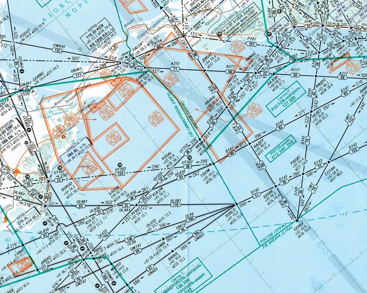
The information we had: 1. Air navigation map (thanks to Lonewolf) 2. BIP scheme (from the court materials) 3. Position of the S-200V site. 4. Tu-143 flight path 5. Tu-154M approximate RCS (thanks to Hpasp). What is still unclear: 1. Time and place of the crash (some different time stamps and locations where stated into the documents). 2. RCS of the Tu-143 (did they used lens, or used it "clear"). Any suggestions how to mix all this in a 3D AAR-like picture? I knew with photoshop could be layered one over another those pics/maps and we could try to extract some flight path coordinates (pretty approximately indeed). Pity, I cannot work with Photoshop, and need help a bit... Also is there a way to put those in Google Earth directly, aany ideas (or it is not needed, due to little effect of earth curvative effect for such a distance)??? Also, we have some expertizes, which needed to be explained (tech stuff about the missile and radars), so anyone could join with help (the best would be a ukrainian PVO specialist  )... It is described here, how to insert an image overlay into Google Earth: https://developers.google.com/earth/documentation/geometries#groundoverlay
Last edited by Hpasp; 08/27/12 01:38 PM.
|
|
|
#3633875 - 08/28/12 06:13 AM
Re: Tu-154M of "Syberia" - what really happens?
[Re: piston79]
|
Joined: Apr 2012
Posts: 635
Alien_MasterMynd
Member
|
Member
Joined: Apr 2012
Posts: 635
Czech Republic
|
ad 2 - I think it is possible, because 5N62 sees its target. And that's probably the reason - they found the target, did not lock 5N62 on it, made IFF check and took the photo.
But in the meantime (because they have not AS) their target went off the 5N62 beam, maybe Tu-154 came into it (but not necessarily), they found out they had no AS, so they reacquired the target, started AS (both in speed and in distance) and launched the missile.
But nobody realized (hurry, stress, lack of time, they did not want to fail during test) they acquired a different target.
|
|
|
#3636296 - 09/01/12 05:29 PM
Re: Tu-154M of "Syberia" - what really happens?
[Re: piston79]
|
Joined: Sep 2011
Posts: 2,011
piston79
Member
|
Member
Joined: Sep 2011
Posts: 2,011
|
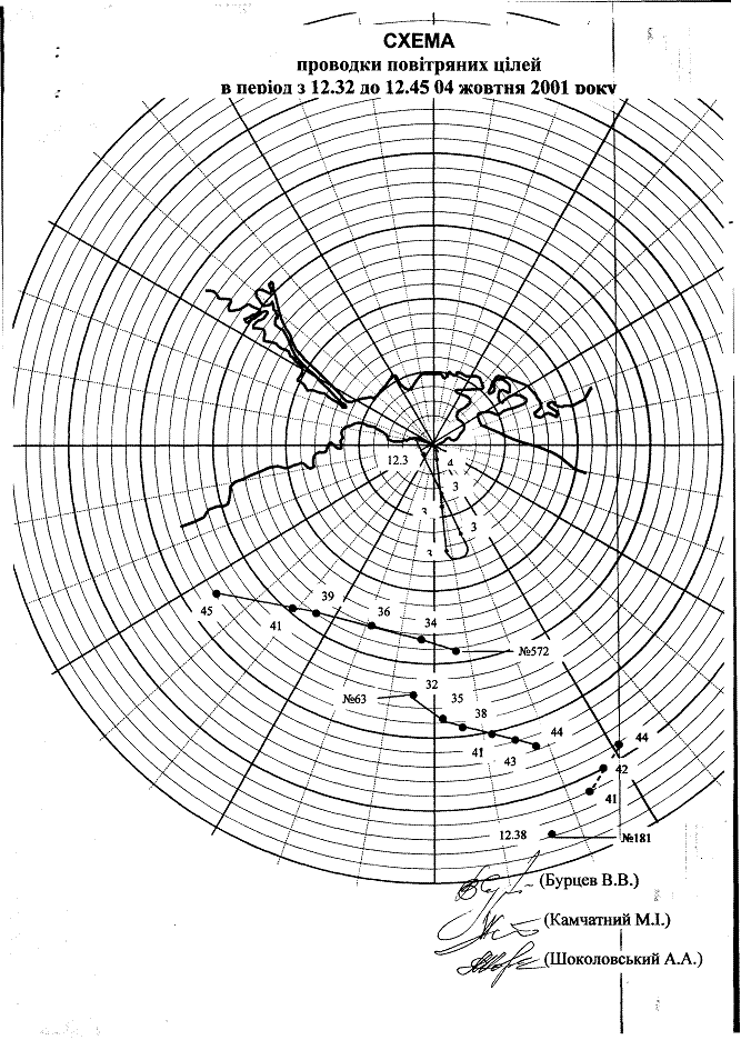
Here, I've just played with some pictures. I am in procces to receive a better image of the BIP, so no need to make it transparent, and than will overlay it again... http://www.mediafire.com/?fucmjym293l2tmg"BIPoverMAP" is the BIP image,calibrated with 150 km lines from east to the west and north to the south. "NavigationMap" is a flight navigation map, which was calibrated over some root points: AMDUS;ODIRA;ALUSHTA and GORNU. It appears that the error is about 5 to 10 km from map to google earth points. At first glance it is obviouse that Tu-154 is pretty far from any root, at least on the BIP... "M" poinst are where wreckedges were found. Black sea water currents are from east to west at this area, so, it looks like the root on BIP is right: 
Last edited by piston79; 09/01/12 05:37 PM.
|
|
|
#3637382 - 09/03/12 03:52 PM
Re: Tu-154M of "Syberia" - what really happens?
[Re: piston79]
|
Joined: Dec 2009
Posts: 2,665
Hpasp
Senior Member
|
Senior Member
Joined: Dec 2009
Posts: 2,665
Hungary, Europe
|
Nice work!  I think, that the NavigationMap should be moved approx 10km to NW. Alushta and Jalta NDB should be on ground? PS: Here is a transparent PNG of the Blotting Board... http://www.mediafire.com/view/?m8x99tds6sut05e
Last edited by Hpasp; 09/03/12 04:09 PM.
|
|
#3637405 - 09/03/12 04:25 PM
 Re: Tu-154M of "Syberia" - what really happens?
[Re: Hpasp]
Re: Tu-154M of "Syberia" - what really happens?
[Re: Hpasp]
|
Joined: Sep 2011
Posts: 2,011
piston79
Member
|
Member
Joined: Sep 2011
Posts: 2,011
|
Nice work! ..For a dumb amateur...  Anyway, thanks for the suport... I think, that the NavigationMap should be moved approx 10km to NW.
Alushta and Jalta NDB should be on ground? I was wondering how to strech it - using shore line or true navigation points...  I Thought at least in the event zone it's quite matched... I am open (and desperately needed) for advices and help, so don't be shine, dear forum mates! Thanks! I just received another one from my friend, will check which one is better.... If find enough time I'll add the Gelendzhik air trafic controll radar position (coordinates are in the court documents), then will give a try for some ".gpx"-es, who knows?
|
|
|
#3637409 - 09/03/12 04:30 PM
Re: Tu-154M of "Syberia" - what really happens?
[Re: piston79]
|
Joined: Dec 2009
Posts: 2,665
Hpasp
Senior Member
|
Senior Member
Joined: Dec 2009
Posts: 2,665
Hungary, Europe
|
... If find enough time I'll add the Gelendzhik air trafic controll radar position (coordinates are in the court documents), then will give a try for some ".gpx"-es, who knows? gpx is easy. Just give me the coordinates/elevation/timestamp for all participants.
|
|
|
#3637564 - 09/03/12 07:11 PM
Re: Tu-154M of "Syberia" - what really happens?
[Re: Lieste]
|
Joined: Sep 2011
Posts: 2,011
piston79
Member
|
Member
Joined: Sep 2011
Posts: 2,011
|
Do you have the original image (with the metadata required for reprojection? Usually marginal notes.)
That's all what I've got: But I didn't get your idea (those shortnames and my pour english bothers me a lot...) 
Last edited by piston79; 09/03/12 07:17 PM.
|
|
|
#3637879 - 09/04/12 05:02 AM
Re: Tu-154M of "Syberia" - what really happens?
[Re: piston79]
|
Joined: Oct 2008
Posts: 3,352
Lieste
Senior Member
|
Senior Member
Joined: Oct 2008
Posts: 3,352
|
Don't worry, your English isn't poor, and I'm able to use what you have (though quality is poor and I'm doubtful of results). Someone check my maths, but I get a surface 'drop' of 4900m over 250km, so the airlane height of 11,112m is 6212m above a horizontal plane at sea level (worst case). This means that a 250km slant range is practically indistinguishable from a 250km 'flat' range ~ the difference being more significant for shorter ranges and higher elevation angles. With these, the plotted Tu154 is over 20km beyond the nominal track of Odira ~ and I'd be surprised by such a large discrepancy in Soviet airspace? The terrain in actuality (SRTM) doesn't match well with either the Air/Navigation chart, nor the plotting board representation, although coordinates recorded are aligned across the multiple documents. Other tracks are similarly displaced further than the route would suggest. The initial impression is one of sloppy calibration and practices, although that might be harsh, as they did successfully engage an airborne target with a single round. 
|
|
|
#3638330 - 09/04/12 07:40 PM
Re: Tu-154M of "Syberia" - what really happens?
[Re: Lieste]
|
Joined: Sep 2011
Posts: 2,011
piston79
Member
|
Member
Joined: Sep 2011
Posts: 2,011
|
Someone check my maths, but I get a surface 'drop' of 4900m over 250km, so the airlane height of 11,112m is 6212m above a horizontal plane at sea level (worst case). This means that a 250km slant range is practically indistinguishable from a 250km 'flat' range ~ the difference being more significant for shorter ranges and higher elevation angles. The distance at which Tu-154 was fire upon was 270 km, which results in about 5 720 meters, which results in a 5392 meters above horizont on 270 km distance i.e. about 1.14 degrees elevation... For the target (BP-3) - 38 km distance against 1.8 km height, it appears 2.7 degrees elevation, still the target should be tracked at heigh 1 - 1.5 km which results in the same angle like Tu-154M ! 
With these, the plotted Tu154 is over 20km beyond the nominal track of Odira ~ and I'd be surprised by such a large discrepancy in Soviet airspace? The terrain in actuality (SRTM) doesn't match well with either the Air/Navigation chart, nor the plotting board representation, although coordinates recorded are aligned across the multiple documents. Other tracks are similarly displaced further than the route would suggest.
Not sure the navigation map was the same at 2001... Should find a way to check it... On the other side, wreckages were found on points M1...M3, which is just on the B145 root! Also the Armenian AN-26 crew stated that near nav. point Rabbit, on 30-40 degrees left, they saw flash and white smoke cloud. By the way, the non-locked SA-5 on the picture - in court documents it is stated that it was done just before the launch, but RPN was not locked!!! GREAT HPASP WE HAD HERE!!!
Last edited by piston79; 09/23/12 11:55 AM.
|
|
|
#3638752 - 09/05/12 10:48 AM
Re: Tu-154M of "Syberia" - what really happens?
[Re: Lieste]
|
Joined: Sep 2011
Posts: 2,011
piston79
Member
|
Member
Joined: Sep 2011
Posts: 2,011
|
It isn't 270km, it is plotted as 260-240km between pts 41-44, according to the plotting board. (280km at t=38 however ~ is there a significance to the 'lost' track for 39, 40?)
The calibrated re-projected 'routemaps' are correct, the 'surface range' rings are good for close in at low altitude and at all altitudes at long range (minimal difference in slant range for max and min height tgt at 250km).
These are projected at 50km, 100km, 200km and 250km on the image over the "azimuthal equidistant" projection. The plotting board range rings are then conformed to these fixed ranges by re-projecting the (somewhat distorted) plotting board image. The yellow line is over 20km long and joins the 'plotted ranges' to the ODIRA route for the t=41 bearing from the radar site. Dear Lieste, I've just quioted the court documents, not your beautifull work! Your approach is quite clever than mine! As i got it right, you created 50-100-150 km circles and then mapped 50-100-150 km rings of the BIP over it, right? I just put this BIP over and adjusting it's size by streching it and measuring the scale, using two 100 km lines from the center to the south and second one - to the east.... The best should if the BIP was tangential to the point of the Command Post (which still cannot understand where was stationed)... But as you stated, the difference is so small (less than 1 km, I think). Target route is also strange - (see the last picture, which I've posted earlier - it is different than on BIP).
|
|
|
#3641339 - 09/09/12 08:19 PM
Re: Tu-154M of "Syberia" - what really happens?
[Re: piston79]
|
Joined: Sep 2011
Posts: 2,011
piston79
Member
|
Member
Joined: Sep 2011
Posts: 2,011
|
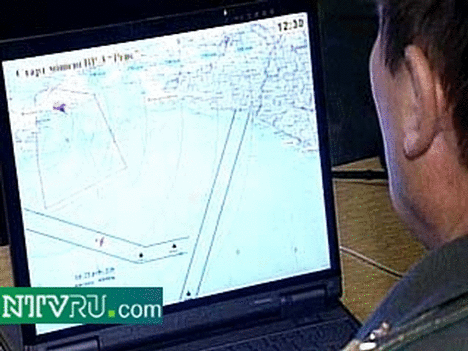
It looks very crappy, but that's what I could do for a moment... Probably picking initial and final point and time will do some smoother speed profile (especially for BP-3 - it goes supersonic, if timing is true!!!). Still, not enough info for the target launch site, also it's obviouse that Tu-154 track should be extracted back in time (just before ODIRA): Know what to do... :  This must be P-18: 
Last edited by piston79; 09/09/12 08:22 PM.
|
|
|
|
|
|
|
|
|
|
|
Exodus
by RedOneAlpha. 04/18/24 05:46 PM
|
|
|
|
|
|
|
|
|
|
|
|